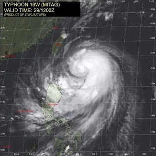
Source: Express, China Daily
Typhoon Mitag has triggered weather warnings for Japan and China as it tracks closer to land and grows in strength. As of the Joint Typhoon Warning Centers latest advisory, the typhoon was packing winds of 80.5mph with gusts reaching 97.8mph. These wind speeds make Mitag the equivalent of a category one hurricane on the Saffir Simpson Hurricane wind scale.China activated a level-IV emergency response for typhoon Mitag on Sunday, according to the Ministry of Emergency Management.
Two working teams have been deployed in the provinces of Zhejiang and Fujian to assist local authorities for preparation.
Mitag, the 18th typhoon this year, is forecasted to sweep the northeast part of Taiwan on Monday night and move north to sweep or land in the coastal areas of Zhejiang province on Tuesday.
From Monday to Tuesday, Mitag is expected to bring heavy rain to some parts of Shanghai and provinces of Fujian, Zhejiang and Jiangsu.
The ministry warned local departments to intensify real-time monitoring, issue alerts promptly, and strengthen evacuation and relocation in areas prone to flooding and geological disasters.
Typhoon Safety
Useful Typhoon Link
17 Relaxing Things To Do During Typhoon Days

No comments:
Post a Comment